|
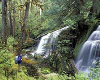
Las Vegas NV (SPX) Mar 05, 2008 Columbus Geographic Systems (GIS) has announced the launch of a new personal navigation solution aimed at the active outdoor and off-road enthusiast. This new feature, incorporated into its popular Ranger navigation unit, lets outdoor travelers select points of interest on their personal navigation device (PND), and then guides them to that location. Ranger is Columbus' cutting-edge navigation software providing location- based, global positioning system (GPS) mapping, navigation, and information solutions for the off-road environment. Ranger operates on a range of devices including Car PC, PDA, and PND. This new feature is very easy to use. Outdoor hikers, mountain bikers or 4x4 drivers simply select a point-of-interest based on category or location, such as rivers and waterfalls, national parks, nature spots, and other attractions, and then use Ranger to navigate to that point. Columbus' new personal navigation solution represents a significant technological breakthrough by pinpointing places-of-interest on raster-based (raster graphics) maps used for off-road navigation applications. "This is the first navigation solution specifically aimed at the outdoor and off-road enthusiast," said Columbus CEO Tsvika Freidman. "Until now, off- road hikers had to use physical maps to navigate to a particular point-of- interest. This advanced application now offers a more effective solution for off-road navigation. We have already built a database of 6,000 points-of- interest and will continue to add new points in the USA and countries around the world." Community Email This Article Comment On This Article Related Links Columbus Geographic Systems (GIS) GPS Applications, Technology and Suppliers
 Moscow (UPI) Mar 04, 2008
The development of Russia's high-tech sector, primarily the national space program, resembles a Camel Trophy race, while official reports do not always reflect the real situation. |
|
| The content herein, unless otherwise known to be public domain, are Copyright Space.TV Corporation. AFP and UPI Wire Stories are copyright Agence France-Presse and United Press International. ESA Portal Reports are copyright European Space Agency. All NASA sourced material is public domain. Additional copyrights may apply in whole or part to other bona fide parties. Advertising does not imply endorsement, agreement or approval of any opinions, statements or information provided by Space.TV Corp on any Web page published or hosted by Space.TV Corp. Privacy Statement |