 |
Berlin, Germany (SPX) Mar 14, 2011 After the severe earthquake and tsunami in Japan, the International Charter 'Space and Major Disasters' was activated on the morning of the 11 March 2011. All participating institutions were asked to provide satellite imagery of the affected area. The German Aerospace Center (Deutsches Zentrum fur Luft- und Raumfahrt; DLR) is responding through its Center for Satellite Based Crisis Information (Zentrum fur Satellitengestutzte Kriseninformation; ZKI), based at its site in Oberpfaffenhofen. "The information acquired by the German TerraSAR-X radar satellite and the RapidEye imaging satellites, together with data from the American WorldView-2 satellite, show the extent of the disaster," explains Stefan Voigt, a researcher at DLR. "The advantage of satellite data is the extensive coverage of the disaster area that it provides. At the same time, we can map details with a spatial resolution of down to 50 centimetres. In the maps we have compiled, it can be seen that the tsunami penetrated 4-5 kilometres inland. The severe damage to roads, bridges, buildings and other infrastructure can be clearly seen. This is important information for rescue workers on the ground. We are working closely with the German Federal Agency for Technical Relief (Bundesanstalt Technisches Hilfswerk; THW)." The scientists and engineers at ZKI began working to provide the necessary assistance immediately after the charter was activated. In close coordination with the control centre and commercial satellite operators, the available satellites were tasked for data acquisition over the disaster area. Since the activation of the charter, an enormous amount of data has been received, processed, analysed, and used to generate the first mapping products; meanwhile, archived data serve as a reference. The damage analysis and situation report are based on the newly acquired satellite images.
Center for Satellite Based Crisis Information ZKI operates at the national and international level and is closely linked with various governmental partners, non-government organisations, satellite operators and space agencies. During the different stages - before, during and after a disaster - ZKI makes various contributions to rehabilitation and reconstruction and for early warning and vulnerability assessment, especially for operational disaster management. In the case of major humanitarian emergencies, international assistance is supported by the provision of maps specifically adapted to meet user's requirements.
Share This Article With Planet Earth
Related Links Terrasar-X Radar Satellite Earth Observation News - Suppiliers, Technology and Application
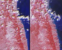 NASA Images Tsunami Impact Across Northeastern Japan
Pasadena CA (JPL) Mar 14, 2011 The extent of inundation from the destructive and deadly tsunami triggered by the March 11, 2011, magnitude 8.9 earthquake centered off Japan's northeastern coast about 130 kilometers (82 miles) east of the city of Sendai is revealed in this before-and-after image pair from the Multi-angle Imaging SpectroRadiometer (MISR) instrument on NASA's Terra spacecraft. The new image, shown on the r ... read more |
|
| The content herein, unless otherwise known to be public domain, are Copyright 1995-2010 - SpaceDaily. AFP and UPI Wire Stories are copyright Agence France-Presse and United Press International. ESA Portal Reports are copyright European Space Agency. All NASA sourced material is public domain. Additional copyrights may apply in whole or part to other bona fide parties. Advertising does not imply endorsement,agreement or approval of any opinions, statements or information provided by SpaceDaily on any Web page published or hosted by SpaceDaily. Privacy Statement |


 del.icio.us
 Digg
Digg Reddit
 YahooMyWeb
 Google