|
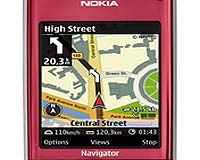
Espoo, Finland (SPX) May 23, 2008 Nokia has announced that its highly anticipated update for Nokia Maps has left beta stage and is now ready for consumers to download. Downloaded over 240,000 times since announced in February, Nokia Maps 2.0 has improved its optional Car Navigation, enhanced its pedestrian navigation, added multimedia city guides, now offers satellite images, and is sporting a redesigned user interface. Nokia's mapping and navigation solutions give people navigation features, local content and world maps directly on their mobile device, in a way that only connected devices can. A partial list of the updated features in Nokia Maps 2.0 includes:
DRIVE - Improved optional Car Navigation equals PND-level car navigation experience with faster routing. - Easy-to-use, updated User Interface features including a new navigation carousel with pre-defined navigation views - i.e. navigation, arrow, bird-eye. - Top-of-the-line navigation features: signposts, multi-stop route planner
WALK - Optional pedestrian navigation efficiently walks you from A to B with visual guidance. It helps you to locate yourself by giving information about the surrounding buildings, streets and parks and, if the device supports it, notifies the direction you are walking. - Nokia Maps 2.0 includes public transportation information (station entrances) data in 17 cities with localized icons for stops. - Advanced multi-sensor positioning using A-GPS, and pedestrian orientation using the compass feature (Nokia 6210 Navigator needed for built-in compass usage)
DISCOVER - Satellite images with hybrid rendering overlays for selected cities worldwide provide real aerial views on your mobile. - Signature "one-box search" allows you to search through places, addresses, restaurants, nightlife, outdoor, accommodation. - New premium multi-media city guides including features photos, video, audio streams. Nokia Maps 2.0 uses vector maps provided by Navteq and TeleAtlas, Nokia Maps now has maps covering over 200 countries, with over 70 of them navigable. Maps can be downloaded over the air directly to selected devices or by using the Nokia Map Loader on a PC. A new beta version of the Nokia Map Loader is available on the Nokia Betalabs web site. Nokia Maps 2.0 and the current commercial version of the Nokia Maps Loader is freely* available for selected devices. Community Email This Article Comment On This Article Related Links Nokia Maps 2.0 GPS Applications, Technology and Suppliers
 Chicago IL (SPX) May 23, 2008
NAVTEQ has announced that Teletrac, a provider of fleet management systems, will integrate NAVTEQ Traffic and NAVTEQ Transport in its newly enhanced Fleet Director product. |
|
| The content herein, unless otherwise known to be public domain, are Copyright Space.TV Corporation. AFP and UPI Wire Stories are copyright Agence France-Presse and United Press International. ESA Portal Reports are copyright European Space Agency. All NASA sourced material is public domain. Additional copyrights may apply in whole or part to other bona fide parties. Advertising does not imply endorsement, agreement or approval of any opinions, statements or information provided by Space.TV Corp on any Web page published or hosted by Space.TV Corp. Privacy Statement |