|
Paris, France (SPX) Jun 18, 2008 Honeywell has been selected by EADS to provide a miniature electronic navigation aid - a Dead-Reckoning Module - that ensures accurate personnel location data in environments where GPS signals are unavailable. "Honeywell's personnel navigator module provides position data even when the user is inside a building or under tree foliage, and this enables better tracking of teammates in dangerous situations," said Werner Hansli, Honeywell Sales Director, European Land Systems. "This miniature electronic navigation aid is extremely valuable for helping to ensure troop safety in urban warfare and combat where buildings and other obstructions block GPS." In urban warfare environments it is essential for soldiers to know where colleagues are so missions remain coordinated and cohesive. Troops need continual awareness of unit members' coordinates for status updates and new battle tactics and orders. In providing accurate position information for the pedestrian user, the light-weight personnel navigator module is attached to the user's vest and when GPS is available identifies the individual's stride length. The electronic aid has multiple sensors - three accelerometer, three gyroscopes, three axis magnetometers and a barometric altimeter - as well as software algorithms that detect and translate the user's motion. When the person steps into a building or under a canopy and loses the GPS signal, the navigation aid takes over and tracks the person's direction and movement to provide a highly accurate position reading. The unit is typically accurate to within two percent of the total distance travelled. Community Email This Article Comment On This Article Related Links Honeywell International GPS Applications, Technology and Suppliers
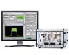 Austin TX (SPX) Jun 18, 2008
National Instruments has announced the NI GPS Toolkit for LabVIEW, an extension of the graphical system design environment that expands the NI RF PXI platform to include multi-satellite GPS signal simulation. |
|
| The content herein, unless otherwise known to be public domain, are Copyright Space.TV Corporation. AFP and UPI Wire Stories are copyright Agence France-Presse and United Press International. ESA Portal Reports are copyright European Space Agency. All NASA sourced material is public domain. Additional copyrights may apply in whole or part to other bona fide parties. Advertising does not imply endorsement, agreement or approval of any opinions, statements or information provided by Space.TV Corp on any Web page published or hosted by Space.TV Corp. Privacy Statement |