 |
Madison WI (SPX) Jul 27, 2010 NASA scientists improved watershed pollution monitoring models by incorporating satellite and ground-based observations of precipitation. The NASA data replaces weather station observations, and will allow states to monitor non-point pollution and improve water quality. The research team, led by Joseph Nigro of Science Systems and Applications, Inc., incorporated two NASA products into a computer program in BASINS (Better Assessment Science Integrating Nonpoint Sources) that calculates streamflow rates and pollution concentrations. The current model uses meteorological data from weather stations, which can miss precipitation events and cause errors in modeling water quality. With better precipitation data, scientists will be able to obtain better estimates of the amount of pollution a body of water can carry before it is determined to be "polluted." The study revealed that both NASA products dramatically improved water quality model performance over the default weather stations. Both systems improved model performance but neither one was consistently better than the other. The NASA data systems were better able to capture the effects of water flow during storm periods that occur frequently in the summer months. This is due to the seamless coverage of the datasets as opposed to a single weather station that cannot represent all precipitation events in a given watershed. The two data products that were selected for this study are the NASA-modified North American Land Data Assimilation System (NLDAS) 1/8th degree precipitation and the Stage IV 4-kilometer dataset developed by the NOAA River Forecast Center Multisensor Precipitation Estimator. The results from the study were reported in the July-August 2010 issue of the Journal of Environmental Quality, published by the America Society of Agronomy, the Crop Science Society of America, and the Soil Science Society of America. The researchers selected seven watersheds within the Chesapeake Bay drainage basin to test the NASA-modified products. They were selected based on their dispersed locations within the drainage basin, an absence of reservoirs or diversions, and the presence of water quality data. Each watershed was also selected based on whether it represented a specific topographic and land cover/land use, so that the study could be conducted within a range of elevations and land cover types to understand how these variations affect the results. The U.S. Environmental Protection Agency (EPA) estimates that over 20,000 water bodies within the United States do not meet water quality standards. The models that this research aims to improve are designed to assessing pollution and to guide the decision making process for improving water quality. The 1972 Clean Water Act requires states to monitor the total daily load a body of water can carry before it is considered polluted. Although states may also monitor water quality with in-stream measuring and sampling, some states lack the resources to assess and protect water bodies with monitoring data alone. Models are a practical solution by taking into account the response of streams to storm runoff and pollution.
Share This Article With Planet Earth
Related Links American Society of Agronomy Earth Observation News - Suppiliers, Technology and Application
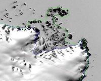 Antarctica Traced From Space
Washington DC (SPX) Jul 26, 2010 Antarctica may not be the world's largest landmass - it's the fifth-largest continent - but resting on top of that land is the world's largest ice sheet. That ice holds more than 60 percent of Earth's fresh water and carries the potential to significantly raise sea level. The continent is losing ice to the sea, and scientists want to know how much. Antarctica's ice generally flows from the ... read more |
|
| The content herein, unless otherwise known to be public domain, are Copyright 1995-2010 - SpaceDaily. AFP and UPI Wire Stories are copyright Agence France-Presse and United Press International. ESA Portal Reports are copyright European Space Agency. All NASA sourced material is public domain. Additional copyrights may apply in whole or part to other bona fide parties. Advertising does not imply endorsement,agreement or approval of any opinions, statements or information provided by SpaceDaily on any Web page published or hosted by SpaceDaily. Privacy Statement |


 del.icio.us
 Digg
Digg Reddit
 YahooMyWeb
 Google