 |
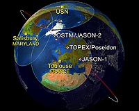
Pasadena CA (SPX) Feb 06, 2009 This artist's rendering shows a "family portrait" of Jason-1, Topex/Poseidon, and OSTM/Jason-2, all NASA satellites that collect data about sea surface heights around the world. Sea surface heights are one component helpful to hurricane forecasters, as higher seas indicate warmer waters (that power storms) while lower seas indicate cooler waters (such as those in La Nina events in the eastern Pacific). This image shows the position of all three satellites on January 28, 2009, as they descended to the southeast, passing over NASA's ground station just outside of Toulouse, France. Glenn M. Shirtliffe, Jason-1 Project Manager at NASA's Jet Propulsion Laboratory, Pasadena, Calif., where the satellites are managed, said, "As a result of the maneuvers performed on January 26 and 27, Jason-1 has now drifted well ahead of OSTM/Jason-2 and Topex/Poseidon, on its way to a new operational orbit on the other side of Earth, 162 degrees ahead of OSTM/Jason-2." The steamy and warm surface waters of the late-summer tropical oceans are the fuel that powers tropical cyclones. NASA's fleet of altimetry missions have often flown over these great storms, charting sea surface height (a measure of the subsurface thermal structure, or heat content). Warmer features like ocean eddies can cause these storms to intensify. Since the altimeters also measure the waves generated by these monster storms, as well as wind speeds, these measurements are routinely used in near-real-time wave and weather forecasts. Jason-1 completed its seventh year on orbit on December 7, 2008. From its vantage point 1,330 kilometers (860 miles) above Earth, this follow-on to the highly successful Topex/Poseidon mission has provided measurements of the surface height of the world's ocean to an accuracy of 3.3 centimeters (1.3 inches). This image from Jason-1 data shows sea surface height data around the world as of December 30, 2008. The purple and blue areas depict sea level heights (in millimeters "mm") lower than normal. One area is in the central Pacific Ocean, which indicates a La Nina event. The red areas indicate higher than normal sea surface heights. The Ocean Surface Topography Mission on the Jason-2 satellite (OSTM/Jason-2) is a follow-on to the Jason-1 mission. It launched June 20, 2008, from Vandenberg Air Force Base in California. "Topex/Poseidon was launched in August 1992 and during its first few days, flew over the monster Category 5 Hurricane Andrew, measuring wind and waves," said Bill Patzert, a JPL climatologist. "Our altimetry fleet was launched during a hurricane and has been chasing cyclones for more than 15 years." Topex/Poseidon is a joint venture between CNES and NASA to map ocean surface topography. Among its many achievements, Topex/Poseidon has measured sea levels with unprecedented accuracy to better than 5 centimeters (X inches), mapped year-to-year changes in heat stored in the upper ocean, and produced the most accurate global maps of tides ever. Share This Article With Planet Earth
Related Links NASA's Ocean Surface Topography from Space Earth Observation News - Suppiliers, Technology and Application
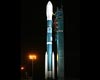 Vandenberg AFB CA (SPX) Feb 05, 2009
The launch of the NOAA-N Prime weather satellite now is set for Thursday, Feb. 5 at 2:22 a.m. PST., weather permitting. Liftoff was scrubbed at 2 a.m. PST Wednesday, when a launch pad gaseous nitrogen pressurization system failed. |
|
| The content herein, unless otherwise known to be public domain, are Copyright 1995-2007 - SpaceDaily.AFP and UPI Wire Stories are copyright Agence France-Presse and United Press International. ESA Portal Reports are copyright European Space Agency. All NASA sourced material is public domain. Additional copyrights may apply in whole or part to other bona fide parties. Advertising does not imply endorsement,agreement or approval of any opinions, statements or information provided by SpaceDaily on any Web page published or hosted by SpaceDaily. Privacy Statement |
 del.icio.us
 Digg
Digg Reddit
 YahooMyWeb
 Google