 |
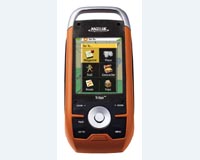
Orlando FL (SPX) Jan 29, 2009 Magellan has announced the availability of its enhanced Triton software with an Improved North American Basemap for an even greater user experience. Magellan reinvented outdoor GPS when it introduced the Triton series by providing outdoor enthusiasts with the most advanced design and innovative features. In an effort to continue providing Triton users leading edge technology, the company has dramatically improved the Triton software to provide enhanced stability, performance and quality of the complete Triton product line. "Magellan prides itself on developing innovative products that provide users with the best navigation experience possible," said Justin Doucette, Director of Outdoor Product Marketing for Magellan's Consumer Product Division. "With the release of the latest Triton software, the new Triton will provide users with the kind of experience outdoor enthusiasts have dreamed of - a rugged GPS navigation device with a full-color touch screen, friendly user interface, built-in camera and media recorder to capture visited locations, and the best mapping solutions available, including access to National Geographic maps and AccuTerra branded GPS map data." The new product update incorporates the following improvements: + User Experience: Users will now be able to enjoy enhanced features including the ability to load and search 500 waypoints, trails with 5,000 track points, and 20 routes; the implementation of the NMEA communication protocol for both USB and Serial communication; trail functionality; and improvements like the ability to select unique trail color in addition to other user-defined trail attribute definitions; and several other user interface and map display improvements. + VantagePoint Software: Users will now be able to take advantage of a Window system trap application that alerts them of new Triton software updates. Additionally, the updated trails functionality and NMEA communication protocol are included in the latest VantagePoint software release to allow users to replay and customize their trails and perform GPS logging. VantagePoint software is available for free download. + Product Accuracy: The accuracy of location information has been updated with improvements in latitude, longitude, heading, bearing, distance, date, time, elevation and speed. The accuracy of the internal memory and SD Card memory readings has also been improved. + Searching: The ability to search for waypoints, geocaches and other place destinations is a vital part of an outdoor GPS device experience. Three areas of search-related improvements are the ability to search user data; the ability to search geographically ("nearest to") a point of the map; and the ability to search for places within a map. + Sensors: Improvements have been made to the functionality and performance of the electronic 3-axis compass and digital barometer; additionally, sensors are only used when necessary, extending the battery life. Two Triton models come equipped with sensors - the Triton 500 and the Triton 2000. + PC and GPS Device Communications: A warning message to users trying to connect their Triton device to their PC for the first time will no longer be displayed as a result of an improved PC connection with certified Microsoft Windows USB driver. + National Geographic TOPO! Explorer: National Geographic SuperQuads - a unique combination of USGS 1:24,000 topo quads, 4-meter aerial imagery and hybrid maps - are now available on Triton GPS devices through TOPO! Explorer and TOPO! Explorer Deluxe software products. New improvements include automatic Triton software updates, updated map export, complete Triton memory management for both user data and NGMaps and updated online user documentation. + Topo USA (powered by AccuTerra): Intermap Technologies branded AccuTerra GPS map data is available to Triton users for online download now, and will soon be available in popular retail outlets. The retail product will be available on "plug 'n play" SD Cards, which can be simply inserted into compatible Triton devices for instant access to national GPS maps. The vector-based interactive maps include property boundaries for federal, state, and local lands; accurate hiking and motorized trails; and over one million outdoor-specific points of interest. Both regional and complete US coverage is available. Share This Article With Planet Earth
Related Links Magellan VantagePoint software GPS Applications, Technology and Suppliers
 Long Beach CA (SPX) Jan 29, 2009
AT and T Business Solutions and WebTech Wireless have teamed up to help the Port of Los Angeles and the Port of Long Beach improve air quality. Under the terms of the agreement, AT and T Business Solutions and WebTech will provide a wireless vehicle tracking and monitoring solution that supports the ports' Clean Trucks Program. |
|
| The content herein, unless otherwise known to be public domain, are Copyright 1995-2007 - SpaceDaily.AFP and UPI Wire Stories are copyright Agence France-Presse and United Press International. ESA Portal Reports are copyright European Space Agency. All NASA sourced material is public domain. Additional copyrights may apply in whole or part to other bona fide parties. Advertising does not imply endorsement,agreement or approval of any opinions, statements or information provided by SpaceDaily on any Web page published or hosted by SpaceDaily. Privacy Statement |
 del.icio.us
 Digg
Digg Reddit
 YahooMyWeb
 Google