 |
Guildford, UK (SPX) Apr 23, 2009 Nigeria will soon be able to map and monitor African resources with local expertise. Nigeria's first satellite imaging engineers are receiving hands-on training at DMCii in Guildford, UK, to manage and process the images NigeriaSat-1 and the future NigeriaSat-2 and NX satellites upon their return to Nigeria. Now in training, Oludare Mabogunje and Kennedy Uti will play a crucial part in Nigeria's future space program, developing African satellite imaging capability for monitoring desertification, land use, water resources and international disasters. The training and development program with DMCii complements the training of Nigerian engineers within parent company SSTL that is reinforcing Nigeria's space program with fully qualified native talent. Oludare and Kennedy balance their weeks between lectures at the nearby University of Surrey, coursework and hands-on satellite image processing at DMCii as part of an intensive 16 month training programme. Mr.Uti explained, "It can be hard work but it's very interesting learning about satellite imaging. We work with DMCii 5 days a week and fit in our studies too. We are also adjusting to the cold weather in England, but the DMCii operational team have given us a warm welcome and we have been learning to use NigeriaSat-1 to acquire images." Mr. Mabogunje elaborated, "One of the most rewarding jobs so far has been tasking NigeriaSat-1 to map the course of the river Niger. There's more to it than just processing the satellite images, for example we had to check the weather reports to plan when to acquire cloud-free images of the river and that's something you can only learn from experience." NigeriaSat-1's imagery is very valuable and effective for mapping changes in land use such as mapping city growth, predicting crop yields and water resource monitoring. The satellite is currently providing regular images in order to map the spread of desertification in West Africa. In separate campaigns it is also being used to map the course of the river Niger and contributing to land use mapping in South Africa. Once the satellite has been told where to take the images ("tasked") using a computer based planning system called an MPS, the images are downloaded from the satellite and processed to turn them into useful information. To date, the Nigerian trainees have also honed their skills response to the International Charter: Space and Major Disasters, which is a global effort to coordinate satellite imaging of natural disasters from space including flooding and wild fires. An important part of the technical training is to learn about image processing techniques that remove distortion from data, and orthorectification - the process of lining up the image data with geographical navigation information so it can used to make maps for governments and relief agencies. Mr. Mabogunje elaborated, "One of the highlights so far was imaging the recent flooding in Vietnam. We chose opportunities to acquire satellite imagery and then processed our own images. Synchronising the images with geo-navigation was the most difficult part because it requires a lot of skill and experience to get 1-2 metre accuracy, but we are learning about these things now." Share This Article With Planet Earth
Related Links DMCii Earth Observation News - Suppiliers, Technology and Application
 Paris, France (ESA) Apr 20, 2009
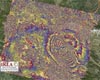
Studying satellite radar data from ESA's Envisat and the Italian Space Agency's COSMO-SkyMed, scientists have begun analysing the movement of Earth during and after the 6.3 earthquake that shook the medieval town of L'Aquila in central Italy on 6 April 2009. |
|
| The content herein, unless otherwise known to be public domain, are Copyright 1995-2007 - SpaceDaily.AFP and UPI Wire Stories are copyright Agence France-Presse and United Press International. ESA Portal Reports are copyright European Space Agency. All NASA sourced material is public domain. Additional copyrights may apply in whole or part to other bona fide parties. Advertising does not imply endorsement,agreement or approval of any opinions, statements or information provided by SpaceDaily on any Web page published or hosted by SpaceDaily. Privacy Statement |
 del.icio.us
 Digg
Digg Reddit
 YahooMyWeb
 Google