|
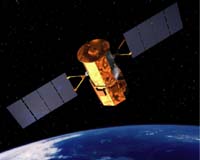
El Segundo CA (SPX) May 14, 2008 Raytheon has completed manufacture and testing of the optics detector module for the aerosol polarimetry sensor. The sensor will ride on the NASA Glory satellite to help agency and other federal officials better understand the impact of aerosols on global warming and climate change. The central component of the sensor, the module contains 161 optical elements, including six telescopes precision-aligned and packed into a tightly compact area measuring less than 130 cubic inches. The module has performed successfully in characterization and optimization testing, representing retirement of most of the risk in the Glory APS program. "With the successful demonstration of the optics detector module, we are well on our way to final delivery of the Glory aerosol polarimetry sensor," said Brian Arnold, vice president for Raytheon's Space Systems group. "We are proud to be a part of this critical mission and look forward to contributing to the science community's understanding of the forces affecting climate change." In orbit the sensor will take accurate measurements of the polarization and intensity of various aerosols in the earth's atmosphere at wavelengths from visible to short-wave infrared to analyze and determine their anthropogenic (man-made) or natural origin. This information will help policy makers comprehend more fully the global processes that contribute to climate change. The Raytheon team is completing the electronics module for the sensor in expectation of delivering the payload to NASA in the fall. Community Email This Article Comment On This Article Related Links Raytheon Earth Observation News - Suppiliers, Technology and Application
 Coalville, England (SPX) May 12, 2008
Aerial survey specialist Bluesky has launched a new range of highly accurate and detailed 3D city models. The new product range will be available off the shelf and will help improve the management of urban centres providing a new understanding of the built environment. |
|
| The content herein, unless otherwise known to be public domain, are Copyright Space.TV Corporation. AFP and UPI Wire Stories are copyright Agence France-Presse and United Press International. ESA Portal Reports are copyright European Space Agency. All NASA sourced material is public domain. Additional copyrights may apply in whole or part to other bona fide parties. Advertising does not imply endorsement, agreement or approval of any opinions, statements or information provided by Space.TV Corp on any Web page published or hosted by Space.TV Corp. Privacy Statement |