 |
London, UK (SPX) Mar 24, 2009 Surrey Satellite Technology Limited (SSTL) will lead a British project to exploit signals from GPS and GNSS navigation satellites that are reflected from the Earth for remote sensing purposes. The project will investigate a prototype instrument capable of measuring the roughness of the sea and soil moisture content, providing data for atmospheric science and for operational ocean and weather forecasting. The world leading small satellite mission provider will lead one of five teams awarded funding by the Centre for Earth Observation Instrumentation (CEOI), the Natural Environment Research Council (NERC) and Department for Innovation, Universities and Skills (DIUS) supported initiative to further technological capability in line with UK Earth observation science priorities. SSTL will lead a team of experts from the University of Surrey, the University of Bath and the National Oceanographic Centre in Southampton. Signals from Global Positioning System (GPS) and Global Navigation Satellite System (GNSS) navigation satellites reflected from land, ice and ocean will be analysed by the instrument, which will fly onboard a separate small satellite. A flexible multi-channel receiver will be developed to detect the reflected GNSS signals for surface sea-state measurements. Using the new remote sensing technique, it is possible to derive important scientific data about the nature of the reflecting surface and the atmosphere, such as the sea-surface roughness or soil moisture content. Sea-surface roughness is important for operational ocean and weather forecasting and impacts many areas of ocean and atmospheric science. For example, the air-sea exchange of gases is controlled by surface roughness. Evidence suggests that the better sampling offered by a new instrument will have a direct impact on our understanding of the magnitude and distribution of atmospheric carbon dioxide uptake by the ocean, with important applications in the prediction of high winds, dangerous sea states, risk of flooding and storm surges. Opportunities to fly this instrument have been identified both through SSTL's own satellite launching capability and through the European Space Agency (ESA) as an approved addition to a future Soil Moisture and Ocean Salinity operational mission (SMOS-ops) to measure soil moisture and ocean salinity. Share This Article With Planet Earth
Related Links Surrey Satellite Technology Limited (SSTL) GPS Applications, Technology and Suppliers
 Paris, France (SPX) Mar 23, 2009
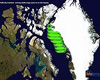
Infoterra has been appointed to undertake an oil slick mapping and interpretation project over Baffin Bay for Nunaoil, the National Oil Company of Greenland. |
|
| The content herein, unless otherwise known to be public domain, are Copyright 1995-2007 - SpaceDaily.AFP and UPI Wire Stories are copyright Agence France-Presse and United Press International. ESA Portal Reports are copyright European Space Agency. All NASA sourced material is public domain. Additional copyrights may apply in whole or part to other bona fide parties. Advertising does not imply endorsement,agreement or approval of any opinions, statements or information provided by SpaceDaily on any Web page published or hosted by SpaceDaily. Privacy Statement |
 del.icio.us
 Digg
Digg Reddit
 YahooMyWeb
 Google