 |
Washington (UPI) Aug 13, 2010 New accurate maps of Chesapeake Bay wetlands will help in studies of areas critical to the health of bodies of water like the Bay, U.S. researchers say. Two U.S. Department of Agriculture scientists used satellite data to created new maps 30 percent more accurate than existing ones, a USDA release said Friday. Because many wetlands are forested, it can be hard to see the wetlands on aerial photography. Trees block the view and maps drawn from aerial photographs are subjective, causing more loss of accuracy, the release said. With the satellite data, Agricultural Research Service soil scientist Greg McCarty and USDA Forest Service ecologist Megan Lang were able to create accurate maps showing flow paths into the Bay -- and determine whether water flows without filtration directly into the Bay, or whether it flows first through forested wetlands that might filter out possible pollutants. Because forested wetlands had been thought to be isolated from each other and the Bay, researchers say, the Clean Water Act did not offer them the same regulatory protections as other wetlands. Accurate maps such as the new satellite versions are vital to Chesapeake Bay cleanup efforts and state and national wetland conservation debates, the USDA said.
Share This Article With Planet Earth
Related Links Earth Observation News - Suppiliers, Technology and Application
 Send In The Clouds
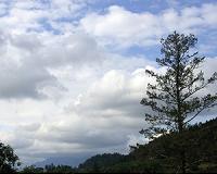
Pasadena CA (JPL) Aug 13, 2010 Gaze up at a cloud-filled sky, and you may spot the white, fluffy shape of a dragon, fish or elephant. Looking at the same sky, Graeme Stephens sees a different vision - a possible future for Earth's climate. Stephens, a professor at Colorado State University in Ft. Collins, is principal investigator of NASA's CloudSat mission, launched in 2006 to improve our understanding of the role clou ... read more |
|
| The content herein, unless otherwise known to be public domain, are Copyright 1995-2010 - SpaceDaily. AFP and UPI Wire Stories are copyright Agence France-Presse and United Press International. ESA Portal Reports are copyright European Space Agency. All NASA sourced material is public domain. Additional copyrights may apply in whole or part to other bona fide parties. Advertising does not imply endorsement,agreement or approval of any opinions, statements or information provided by SpaceDaily on any Web page published or hosted by SpaceDaily. Privacy Statement |


 del.icio.us
 Digg
Digg Reddit
 YahooMyWeb
 Google