 |
Leicester, UK (SPX) Oct 18, 2010 SymetriGEO Services, part of Astrium Services' GEO-Information division, is supporting the Geospatial and Situational Awareness Demonstration, which is part of the UK Ministry of Defence (MOD) sponsored Common Geospatial Tool Set (CGTS) research project. The objective of CGTS, which is being delivered by the Lockheed Martin (UK) led Team SPARTA, is to de-risk future geospatial capability procurement options and to support the delivery of a coherent geospatial capability across the UK MOD. Earlier this year SymetriGEO was involved in the delivery of a demonstration highlighting "the art of the possible" in 2012, based on a Homeland Security scenario and focusing on the operational benefits of an open-standards based approach. Phil Cooper, SymetriGEO's business manager commented:"we are delighted to see ERDAS products, and especially ERDAS APOLLO, utilised within a fully collaborative environment and we are fully committed to help ensure the success of the CGTS capability demonstration." John Tate from Lockheed Martin noted: "the support received from SymetriGEO has assisted in the illustration of the delivery of an open-standards based geo capability across the security sector and UK MOD." The third and final demonstration will take place at Lockheed Martin (UK)'s Swift facility (Farnborough) until the 15th October, and will focus on interoperability and include geospatial capability investigations, such as cross-country movement, cultural geography and uncertainty. Taking full advantage of the fully-integrated combined resources and skills of its Spot Image and Infoterra subsidiaries, the GEO-Information division of Astrium Services has become a recognised world leader in the geo-information market by offering decision-makers sustainable one-stop-shop solutions to increase security, protect the environment, and better manage natural resources. It has exclusive access to SPOT and TerraSAR-X satellite data, while also calling on a full gamut of space data sources and airborne acquisition capabilities, enabling it to offer an unrivalled combination of Earth observation products and services. Its portfolio spans the entire geo-information value chain. By building on the synergy of Astrium Services, the GEO-Information division can also develop innovative solutions combining Earth observation, navigation and communication applications at competitive prices.
Share This Article With Planet Earth
Related Links Astrium Earth Observation News - Suppiliers, Technology and Application
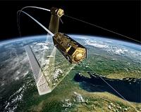 Satellites join up to map Earth
Berlin (UPI) Oct 15, 2010 Two German satellites orbiting within 380 yards of each other are preparing to create the most detailed map ever made of Earth's entire surface, officials said. The radar satellites TanDEM-X and TerraSAR-X will make 3-D maps of the surface as they orbit the globe, sweeping around the planet at more than 14,000 mph, the BBC reported. TerraSAR-X was launched in 2007 and TanDEM-X wa ... read more |
|
| The content herein, unless otherwise known to be public domain, are Copyright 1995-2010 - SpaceDaily. AFP and UPI Wire Stories are copyright Agence France-Presse and United Press International. ESA Portal Reports are copyright European Space Agency. All NASA sourced material is public domain. Additional copyrights may apply in whole or part to other bona fide parties. Advertising does not imply endorsement,agreement or approval of any opinions, statements or information provided by SpaceDaily on any Web page published or hosted by SpaceDaily. Privacy Statement |

 del.icio.us
 Digg
Digg Reddit
 YahooMyWeb
 Google