 |
Bonn, Germany (SPX) Dec 28, 2010 From over 500 kilometres up, as TerraSAR-X looks down on its icy surface, the Antarctic's Nimrod Glacier looks like molten metal. During its flight over the Antarctic, the German Aerospace Centre's (DLR) radar satellite is one of the few that can direct its view over this glacier in the Transantarctic Mountains. Researchers can use these images from space to determine the flow speed of the glacier. Polar explorer Ernest Shackleton may not have completed his quest to be the first to stand on the geographic South Pole on his first Antarctic exploration (1907-1909), but his expedition was such a success that his ship, Nimrod, gave its name to the glacier. The glacier is 135 kilometres long (82.5 degrees S, 160 degrees E), working its way from the polar plateau through the Transantarctic Mountains, a range of mountains that runs across the entire continent of Antarctica at heights of up to 4500 metres. While it moves, it transports ice from eastern Antarctica to the Ross Ice Shelf. The glacier can move up to two metres per day. "The flow speed is an important indicator in understanding the dynamics of the polar ice sheets," says Dana Floricioiu from the DLR Remote Sensing Technology Institute. "The polar regions play an important role in the Earth system - changes influence climate models with a local impact on the properties of the polar oceans as well as a global impact on rising sea levels." This detailed image - acquired by the TerraSAR-X radar satellite and having a width of about 30 kilometres, shows the glacier flowing around the Kon-Tiki Nunatak, a rock protruding through the ice sheet. It is even possible to pick out the fissures in the glacier's main body.
The South Pole in view The DLR scientists had the satellite look to the left to capture these images. "Radar satellites are typically designed so that their line-of-sight is to the right of their flight path. That's why they cannot observe regions with a latitude of more than 80 degrees south over the Antarctic," explains Floricioiu. "But with TerraSAR-X, by rotating the satellite we can select the direction of the antenna beam so we can even capture areas close to the South Pole." Because the radar satellite images the Earth's surface regardless of cloud cover or time of day, it can systematically observe the properties of land and oceanic ice even in remote regions, all year round. At a very high resolution of three metres, the researchers are able to observe and analyse in detail the complex in-depth structure of ice and snow-covered regions.
Share This Article With Planet Earth
Related Links German Aerospace Center (DLR) Earth Observation News - Suppiliers, Technology and Application
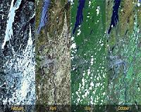 Season's Greetings: NASA Views The Change Of Seasons
Pasadena CA (SPX) Dec 22, 2010 The change of seasons on Earth has been a cause for celebration since time immemorial. Caused by the tilt of Earth's axis relative to its orbital plane around the sun, seasons have profound changes on our weather and climate. When seasons change, nature reacts differently, depending on location. Temperatures change, rain or snow falls, rivers may flood, to name just a few effec ... read more |
|
| The content herein, unless otherwise known to be public domain, are Copyright 1995-2010 - SpaceDaily. AFP and UPI Wire Stories are copyright Agence France-Presse and United Press International. ESA Portal Reports are copyright European Space Agency. All NASA sourced material is public domain. Additional copyrights may apply in whole or part to other bona fide parties. Advertising does not imply endorsement,agreement or approval of any opinions, statements or information provided by SpaceDaily on any Web page published or hosted by SpaceDaily. Privacy Statement |


 del.icio.us
 Digg
Digg Reddit
 YahooMyWeb
 Google